Saturday, January 30, 2016

Eruption in style

Let's start with a special beauty: McDonald Island on a windy, clear sky day:


McDonald from distance

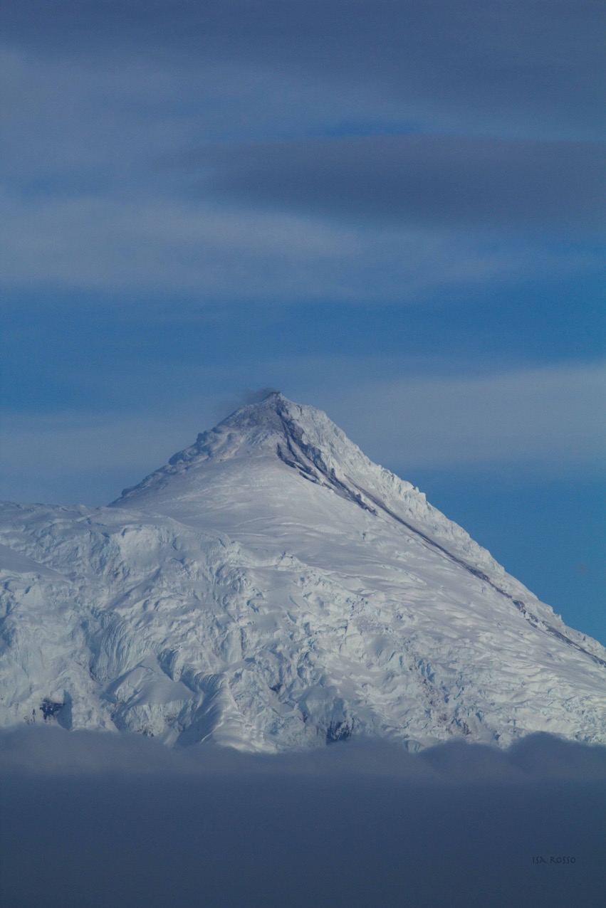
Not bad, uh? And what about a close-up.. with Mawson Peak of Big Ben mountain (on Heard Island) visible from distance?? There's a layer of mist below, which makes the mountain looks like floating in the air.. A bit like a "Castle in the sky", as one of the scientists commented ("Laputa: Castle in the Sky" is also one of my favorite anime from H. Miyazaki). And also: can you see that black line the runs diagonal from the peak of Big Ben? Well.. guess what.. that's lava!!! 


South-west side of McDonald island, with Mawson Peak visible in distance.


I feel, once again, privileged. Not many can say to have had the chance to see Big Ben in its beauty. Well.. I guess not many can say to have been here in these waters, either.. right? That makes me think: how many Italians have been here? :-) 

Heard Island has been discovered in 1833, or 1853, and has been visited only few times, as it's quite inhospitable. Lava and ice are the 2 players responsible for its morphology. Jodi Fox, our geologist aboard, teaches us that, despite Heard Island is just 44 km distant from the McDonald islands, it shows a very different type of lava and, hence, a different eruptive style.. as these things go. Heard's kind is smoky, with high plumes, but doesn't produce big explosions. McDonalds' eruptions, on the other hand, are more explosive. With its top at 2745 m, Big Ben is the second highest mountain of the Australian territory and Australia's only active volcano!

Having the chance to SEE Heard Island is rather rare. The weather here is really bad (I probably said that "few" times) and there's always a thick layer of fog and clouds surrounding the island. We've been mapping the bathymetry around McDonald Islands for many days now, and the weather allowed just few other research activities. But every now and then, when on the right side and at the right moment, Heard Island has been has gifted us with the vision of some of its features..


One of the glaciers on Heard Island (I forgot to ask Jodi which one..), diving into the ocean.


A "pretty good" day to get more details of the island..


One of the skills of a good researcher is patience.. I believe. And I think that this time this gifted us in a magical way…

Tonight, the call from the bridge: "Big Ben's erupting!"!!!!

We all know what happens next, right? Rush to get cameras, lenses, jackets, beanies, etc. and up to the bridge! And because this was more than sensational, we just ran outside, challenging the painful wind.. In between smiles and laughs and "I cannot believe what I'm seeing", we all had our chance to get some thousands pictures of the event.. (I had a really hard time choosing the photos to post). This is a taste of what was in front of our opened-wide eyes:


Heard Island in all its beauty!


Close-up of Big Ben.


Eruption of Big Ben with lava on the side.


As quick as it showed itself, Big Ben wrapped itself up in a thick cloud.. We all sent our goodbye and went back to our work.. with pure joy in our hearts.. and a memory to share.


Time to hide again..


Tuesday, January 26, 2016

Penguins rolls

It went like this: it's breakfast time for me (1pm, ish), a bowl of milk and cereal, particularly hot, in one hand and a coffee in the other. The boat rolls (a lot) and my eyes point to one of the portholes in the galley: water, water, water.. waves.. a gray huge silhouette of… what!? It can't be a wave THAT big! I run to the porthole (carefully, not to drop my precious meal on the floor) and.. here it is!! just behind that thick fog, McDonald Island! One of the most remote places on Earth is just in front of my eyes! Useless to say that I basically swallow the whole breakfast (not a great idea.. the temperature makes it more like lava, rather than milk), run downstairs to the Operations Room, get my camera (with my 3 lenses.. you never know if you have something close, something far.. or something wide) and 5 floors up to the bridge (now.. "run": the big swell made my inglorious run more like a series of fast fast steps alternated to reaaaaally slow ones). And that's what I see..


McDonald Island, view from the bridge

It's really something unexpectedly emotional to see land after almost 20 days of a 360 degrees view of ocean and sky, sky and ocean. A very dramatic view, in this case, as with its sharp profile, its dark volcanic rocks, fumes that emerge from several points, a fog that blends everything around in a monochromatic gray tone, waves that violently brakes against its figure, thousands penguins standing at the top of the mountains (seriously.. what are they doing there?!) and elephant seals fighting on the small beach (now, here I had to trust the others, as I couldn't really see them with my eyes).. McDonald Island looks like it's coming out from a fantasy book. At any moment, I expect to see a dragon emerging from one of those rocks ;-) The island has a volcanic origin. Satellite images show that it has doubled its size (!!) between 1980 and 2001, probably due to an eruption in 1997. And it might look very inhospitable to us, but no doubt it's the perfect home for many animals.


Thousands of penguins are at the top of the mountain! (they're very little on the picture.. just trust me: I saw them with the binoculars)

There are many many more seabirds, as little as storm petrels and as huge as wandering albatrosses. Groups of penguins and fur seals jump crazily through the big waves.. we wish we could see killer whales too. Penguins are incredibly fast, which made my photographic hobby particularly challenging. 


Few seals jumping in the waters in front of McDonald Island


A group of Macaroni penguins


Awww.. this is so cute!!


Ok, last photo of penguins!

We've been spending these last 3 days around the island, as the weather is pretty bad and we cannot safely stop to take any measurements. So, we've been mapping the seafloor around, looking for bubbles from the ocean floor to track any potential hydrothermal vents (not an easy task, I must say). We've been playing tennis table, watching movies (Captain Phillip was my favorite), eating an enormous quantity of cake, cookies, ice-cream, pudding. While the ocean on the shallow plateau continued to rage.

2 days ago, I was watching a movie with a group of us. All of a sudden, the roll of the ship became stronger and stronger: I made a fortress with a couple of couches, so I didn't really move much from my position. But it wasn't so still for the rest of them: people started sliding on the floor, with or without a couch or a chair. Sliding back and forth. At the beginning, it was pretty funny, I admit. Some were laughing by the incapability of being able to stand up for more than few seconds. 1, 2, 3 rolls and then.. BOOM! Everything went flying against the other side of the room: couches, chairs, tennis table, people! Fortunately nobody in the room got injured.
Plot of the roll of the ship: indicated in red is the vicious one.

The galley was a mess (pun intended ;-P ): we had pudding and raspberry jelly as dessert for dinner.. it was everywhere! Sadly one of us slipped on the floor and twisted her knee, but fortunately she's already recovering and nothing major happened. From the bridge, Pete, our video/photographer took an amazing picture of the roll (which you can see below)… before he went flying across the bridge, to then violently land with his nose on the desk :-( Fortunately again, no broken bones or nose, just a bad bruise. But we all got a very important lesson here: "one hand for the ship.. and with this weather, better keep two!".


Pete's shot during the roll, before he flew towards the desk (credit: Pete Harmsen, CSIRO/MNF)


One last thing: Happy Australia Day to all my Aussie friends! We had a lot of fun celebrating it here: BBQ, pavlova, flags everywhere, the Triple J 100 best songs. Love it!! :)


Saturday, January 23, 2016

Bird watching lesson from the Kerguelen Plateau

Albatrosses and petrels, constant companions of our journey, are majestic indeed. I had a bit of time yesterday to admire their turns, their perfect aerodynamic shape, their confident look. It was such a gorgeous sunny day! Not warm, though: air temperature was about 3 deg C and the wind so strong that I had to wear my beanie, wool gloves, snowboard jacket, wool socks, waterproof boots.. which really didn't protect me from freezing. And the wave that caught me on the back deck? Didn't feel that warm either.

But in that half an hour or so, I took out my camera, my zoom lens and had a bit of fun by trying to capture their freedom on my artificial memory. Not an easy task, I must say, with a moving boat and their fast flight. Their turns are so elegant, so perfectly calibrated. Sometimes they just barely touch the thin ocean surface with the last bit of their feathers, or they appear just below a breaking wave. Just a touch, an intimate exchange with the never stopping, troubled, immense blue. Always tending to each other, bird and ocean. One with its mesmerizing flight, the other trying to capture it by over stretching in the form of a wave. It's like they play, never really tired of doing so. 


Wandering albatross


Cape petrel


Prion (unfortunately I couldn't get the right focus on this fast bird very well.. but you get the idea)

I had a chat with Fernando Arce, a PhD student at the Institute for Marine and Antarctic Studies and the Australian Antarctic Division in Hobart. Hemhas a background in terrestrial ecologist, however he's finding his path to the ocean "much more interesting and definitely more challenging". On board, he's one of our wildlife observers (how cool is that?!). Despite our contrasting views on which one, bird or whale, is far more beautiful than the other (I stand for whales, of course), he happily instructed me on the bird life we are encountering in these days. For example, so far he spotted 45 species of seabirds, with 8 types of albatrosses (such like those big guys in the first 3 pictures above) and about 20 kinds of petrels, from the sub-tropical Barau's and Round Island petrels to the sub-Antarctic Kerguelen and Cape petrels (oh, these are really beautiful: did you see the Cape Petrel above? how amazing is the pattern on its feathers?!). He told me that there are about 17 species of albatross in the Southern Ocean and as much as 10 just here in this region. I always see them flying, sometimes floating on the ocean (maybe to get some rest?), but I never actually see them eating. I wondered how long they can stay with no food… Fortunately Pete got the proof that they actually get something to eat. We can see them here, but they have a nest on some islands. They leave their nest when they are 6 months old, more or less, and then live for few years at sea, spending their youth in freedom. They normally mate for life, but divorces (?!) are not uncommon (e.g. if the couple fails to successfully raise a chick, after several attempts O.o ). Fernando loves everything about them (and you can see it in the sparkles of his eyes..), especially their effortless looking flying motion, their ability to fly over very long distances and even circum-fly Antarctica and…"because they are cute!". For his studies he's taking in situ information about their diversity, distribution and abundance, as so far not many data have been collected. Some of them unfortunately are endangered, especially the large albatrosses as they are a bycatch of long lines :-( To protect them, a network of protected areas is currently under development.

Fernando also spotted pilot, sei and humpback whales (Tim, the other wildlife observer, even spotted a blue whale!!), bottlenose dolphins, fur seals and penguins, but, as I have previously said, I haven't seen any of them.. with my deep despair.. 


A mollymawk albatross

A white-chinned petrel (on the left) and a black-browed albatross, on the right (it looks like this guy has a mask on his eyes..)


That's all from the bird life :-)


Goodbye form the brown skua..

Wednesday, January 20, 2016

Some yellow in the fog

Tadaaaaa!!! :D

Here I am again! I haven’t been able to update the blog in these last few days, as I had a reeeeally busy time and had to use those few free hours to get some rest (although they didn’t protect me from being called “Zombie girl” by Tom hahaha!!).

Anyway.. a lot of exciting news from the Indian Ocean!! 

First: I’m sure that all the students from the John Witherspoon (JW) Middle School will be very thrilled to know that.. their first float, JW, has already sent its first profiles (which you can see below)! Another success!!! Whooohoooo!!! 


JW’s is well and has sent us it’s first data!


The excitement has not finished yet: another SOCCOM float (the third of this voyage) has begun its journey! The JW students called the Apex 9757 Nemo. I love it! :) Our artist-on-board Annalise drew the Disney character on the yellow skin of the float:


Annalise draws Nemo on the float (that’s impressive: I don’t really know how she can do that on a curved surface)

The float has been named Nemo not just for the cute and brave clown fish with a foreshortened fin, that we all fall in love with (I confess that when I went scuba diving in the warm waters of the Great Barrier Reef, I searched for him). Nemo is also the enigmatic captain of the Nautilus, the 20000 Leagues Under the Seas submarine born from the wild imagination of Jules Verne. As Captain Nemo, the float will indeed be in an underwater tour of the world, in a mission risen from our scientific thirst for knowledge. Will it have to battle against a school of giant cuttlefish, too?

For the next 5-7 years (depending on how long the battery will last) JW and Nemo, while collecting data, will drift with the currents. Where will they go? Well, this is a hard question, as their trajectories will depend on the type of circulation they’ll encounter. JW has been deployed inside the core of an eddy, so it might be trapped in the eddy for a while (months or more, sometimes). Or, maybe not. Predicting the exact path it’ll have in, let’s say, years is not really possible, due to the nature of the ocean: currents and eddies mix waters around, in some places as strong as a a giant blender. Existing data, such as previous Argo floats that have passed close to the location where the JW and Nemo (and Jose' before, of course) have been deployed, can give us an idea of possible trajectories. Also, with numerical simulations we can model the circulation and test the possible pathways that a float could take. To do so, we can release some float-like-particles in our model and see where they go. And we can put thousands of them in the model, so that we can have a better estimate of where they most likely be in 1 year, 2, 3… etc. Have a look at the movie below, which shows where some of these float-like-particles are transported by modelled currents: in every colored point there are hundreds of them and the lines show their paths.

Modelled trajectories

I guess that if you really wanna know where these floats are, keep an eye on the SOCCOM website ;-)

My last surprise for today is Nemo’s first profiles!!! :D All the sensors are working perfectly and I cannot be happier to see that! As you can see from the temperatures close to the surface, Nemo has been deployed in colder waters with respect to JW and Jose', as we are heading south, and we are closer and closer to Antarctica (we won't go that far, though, this time). Nitrate concentration is also higher in the surface waters, compared to what JW has found. Every 10 days we will receive data like this, which will allow us to unravel new stories to tell.


Nemo’s first profiles!


I haven’t been out much in these days, unfortunately. Apparently, we had an astonishing sunset, a beautiful sunny day, whales, seals and penguins (uhm. I think that at this point my ship-mates are just making fun of me..). Oh well. All I could see from the porthole in the past few hours was fog. Very thick. Very bright.. fog.


The world around the ship has disappeared.. 


Sunday, January 17, 2016

A long exciting day in the Southern Ocean

I got up yesterday morning at 10 am, after 6 hours of sleep. I did my 55' of run and my boxing drills, which gave me some energy for the day to come.. a long and with lots of excitements day !

I gave my talk, which went spectacularly well :-) Usually we have talks lasting more or less 30', question time included. Mine took a whole hour!! I think I never got so many questions and so much active discussion.. haha!! It was awesome!! And what a beautiful day, too! The sun pushed us to spend a longer and much more pleasant time outside, even under a chilling wind, which froze our fingers in the attempt of taking photos. We all waited with great expectation for the sunset (which happened around 9.30 pm), as we knew it would have been spectacular.. And quite rare, as clouds usually cover the sky at these latitudes. 


An albatross, master of the wind, flying free around the ship.


Sunset view from the bow


Some relaxing time at the bridge

We then deployed an Argo float (similar to a SOCCOM float, but with only temperature and salinity sensors) for the Argo program, an international collaboration that collects profiles of temperature and salinity from ice-free global oceans (if you want to know more: www.argo.ucsd.edu). The lauch was super easy, as they are deployed inside a cardboard box which opens in just few minutes once in water. Pete Harmsen from CSIRO/MNF got a very nice video of the operation, which I post at the end of the cruise as we have a very limited internet connection.

As we were heading towards the next station, I got the second SOCCOM float ready: sensors cleaned and new "look" prepared.. This float has been named John Witherspoon, as it is the name of the Middle School in Princeton (NJ) which I am in contact with (Hi guys!!! :-D ). The history teaches me that John Witherspoon (1723-1794) had quite an interesting life: he was the only active clergyman among the singers of the Declaration of Independence, elected to the Continental Congress and then to the state legislature in New Jersey and finally president of the College of New Jersey from 1768 to 1792, which is now known as Princeton University (!!!).

To this man and the John Witherspoon Middle School, this float is dedicated to! The next floats will be named by the students of the school ..and I have a special surprise for them, as I got Annalise Rees, a very talented artist that we have the pleasure to have aboard, involved in the decoration of the floats! (If you want to know Annalise's work, have a look at her websites: www.annaliserees.com and www.annaliserees.blogspot.com.au).


Annalise on the left, John Witherspoon float in the middle and me, on the right, wearing a wolf-ewok-teletubby-koala (open to interpretations) beanie that I knitted myself ;-D 


Float #9645 waits for its dive outside on the back deck, while curious albatrosses and petrels fly around.


Deployment of the float from the back deck (..it was roughly 4 pm, local time).


I haven't slept much in the last 30 hours and won't sleep much for the next 30 as well, but we have a great coffee machine, which is my best friends in these days (in perfect italian style, I drink MANY espressos!).

Of course during this long day we didn't just deploy the floats, but many different operations have taken place (1 in particular regards the calibration of our float), but I think I'll talk about them another time, as I have to go prepare the next float and maybe have a nap before the next action. Till the next time, Ciaoooooo!!!


ps: we are taking drawing classes with Annalise and both the ship crew and the scientists got very excited. I think we all have an hidden talent.. somewhere.. I hope I'll find mine by the end of the cruise ;-)


First drawing class creation.. I'm not really sure where I left my talent.. maybe I sent it away with the first float.. ha! ;-)


Friday, January 15, 2016

A message from the abyss

Float #9749, the first SOCCOM float launched from the RV Investigator (yes!, the one that carries Jose' as name :-) ) has spoken!! The first profiles have been sent via satellite to the Monterey Bay Aquarium Research Institute (MBARI) lab, where they have been interpreted and plotted. And here is what they look like:


The plot shows depth profiles (depth is on the x-axis) of pH, oxygen, temperature and nitrate. Look at that peak in oxygen (red curve) at about 100 m: that's due to phytoplankton using CO2 and releasing oxygen. pH is also indicative of the biological activity. Temperature and high values of oxygen in the first 400 m are indication of a water mass called "Mode Water". While below that depth, we have the Antarctic Intermediate Water, with a minimum in oxygen. 

What an exciting moment!! Yesterday I received this plot on my email and I almost (well.. I actually did) screamed for joy! :-). I was so nervous, waiting for the first sign from the float. "What if the sensors did not work? What if the float has hit something?".. that kind of stress. You feel responsible, you have a mission to accomplish, that you've been planning long in advance.. everything must be perfect! We want data, we need them. We wanna know what's happening below the surface of the ocean, understand what the occurring physical, biological and chemical mechanisms are, how the oceans are changing. Especially here, in the Southern Ocean. Due to many reasons (one for sure is the brutality of the weather and ocean conditions, that make any operation very very difficult), observations have been minimal here compared to other parts in the world. But we are getting more and more of them, as the scientific community has recognised the importance of the Southern Ocean for the whole climate system.

What's so special about the Southern Ocean? This ocean, located south of, let's say 30 deg S, connects the Indian, Pacific and Atlantic oceans, stirring their waters and mixing their properties. It also serves as link between the surface and deep waters (note that, the circulation of the oceans around the globe is very complicated: waters that flow at the surface can sink in different locations, which are then transported at depth to different parts of the world and finally rise again to the surface, somewhere else.. after a time scale of up to thousand years!). While transporting waters up and down in the water column, different dissolved gases are exchanged and transported too. For example, in the Southern Ocean there are places where the water sinks and, by doing so, transports down to depth the atmospheric gases that the ocean has been in contact with, through the ocean surface. For example, carbon dioxide. But there are other locations where the waters are upwelled, and those dissolved gases brought back to the atmosphere. Recent studies found that, of the total amount of carbon dioxide due to human activity absorbed by the global oceans since 1750, the Southern Ocean alone may have absorbed up to a half. Carbon dioxide can enter the ocean also via another process, which is due to the enhanced solubility of carbon dioxide in cold water, rather than warm: so, surface waters flowing towards Antarctica get colder and uptake carbon dioxide; while waters going towards the warmer tropical waters release it. We also need to add the role of biology in the Southern Ocean, which I talked about in a previous post, to this picture, as it's a fundamental process in the uptake of carbon dioxide. Adding carbon dioxide into the ocean cools the atmosphere, while releasing it into the atmosphere warms up our climate. So, to wrap it up, because of the physical circulation, the biological activity and the solubility in the Southern Ocean, it comes that this ocean has a pivotal role in the climate system. Any changes to either the physical or the biological or the chemical world in the Southern Ocean can have a dramatic impact in the global climate system. 

That's why it's so important to improve our knowledge of the Southern Ocean!

I have other 6 floats to deploy on this voyage and the next one will soon be prepared, as it will be launched 24 hours from now! Fantastic!! The weather has also been nicer today and someone spotted some pilot whales (I was at the gym, so no whales for me :-( ). Tomorrow is gonna be very intense, as we'll have many many activities to do (I'll show you in few days what we've been up to). But, before that, I gotta prepare my talk for tomorrow! Talks on a ship are a really good way to get to know each other's interests and learn something new.. For example, do you know that if a ship sails over a gas leak, because the ship becomes less buoyant than the surrounding water, the ship could sink? That makes me think.. We are looking for an underwater volcanic field.. which releases gas. uhm… just saying… O.o 


Wednesday, January 13, 2016

White horses


The world fades away in front of us..

41° 48' S, 94° 23' E: we are steaming towards the next station. The ocean calmed down just for a small window of time.. and it's now showing us its power again. The horizon looks dramatically grey (one can wonder what's waiting for us behind that grey thick curtain of mystery..). In just few hours we'll go from winds coming from north, to a low pressure system, with strong winds from west to east. The "Roaring Forties", that's how the westerlies between 40° and 50 ° S are called.. you can even hear that roar! We are "dancing" again and even if the waves are not very high (about 5 mt), they are powerful. We had to put the thick and very heavy cover to the portholes, as the waves are violently smashing against the side of the boat.. 


From the bridge, I admire this infinite train of waves.. so powerful, so free.


I spent most of the day at the bridge, taking pictures, sharing sailing stories, planning the science operations for the following days and talking about what we are about to experience, in terms of ocean conditions, in the next few hours. I'm particularly excited when the weather becomes rougher (unless it's when we have to do our planned operations). Being at sea reminds me of the long path that brought me here.. 

I've always been fascinated by the power of the sea. As a young girl, the best time of the year was August, which for me it meant being on a Zodiac, in the Mediterranean Sea (I'm Italian), to catch waves, explore the sea in freedom and be surrounded by that deep blue. Few years passed, and I found myself enjoying physics and maths (pretty interesting, considering that till that moment I never liked school so much.. LOL!). I took a year-long break after high school to work and do my sport (at that time, javelin was my passion), then decided to take a degree in Physics.. 3 years later, I had finally my first lesson of "Oceanography". I remember looking at a photo of a rogue wave taken aboard a ship in the North Sea, a "monster" something like 25 mt high (!!), and thinking how magnificent it was (yes, I know.. a normal person wouldn't have had such thoughts.. I never said I was "normal" ;-) ). Rogue waves (also called "freak waves") come like ghosts, out of the blue, completely unpredictable. But their immense power is so destructive that many ships have been sunk because of that.. and, sadly, many lives have been lost..


In 2005 a seven-story wave off the coast of Georgia, appeared out of nowhere and crashed against the Norwegian Dawn.

After I graduated with a master in Environmental Physics, it took me few years full of different experiences, multiple jobs, travels, setbacks, before I listened to the call of the ocean again and decided to do research in Oceanography. I moved to Australia in order to do that, where I took my PhD in Oceanography. My project was about modeling the Southern Ocean and soon I became very fond of this part of the planet. I always loved modeling, but whenever I had the opportunity, I was also very ready to jump on a boat to explore the hidden secrets of our oceans. My path brought me to San Diego, where I have the great opportunity to continue to explore the Southern Ocean, both from behind a computer screen and on a rocking boat!

I never complain to be under strong rain or freezing winds or burning sun, if I can have a 360° ocean view from my office window. Few years ago I had a dream.. now I'm fulfilling it!


Tuesday, January 12, 2016

Hasta luego, Jose' the float!!

What an exciting and full on day! The first SOCCOM float has departed for its adventure, deep in the Indian Ocean.. searching for secrets to reveal. Our first float has been named José Iriarte, as José (from the Universidad Austral de Chile, UACh) has won last spring's contest launched on the SOCCOM research blog. The contest asked people to guess the maximum chlorophyll concentration a float would measure, and José got it right. Very good job, José! I wish I could put my name too.. hopefully there will be another contest next spring ;-)


José's float and its friend (soon you'll know how it'll be named ;-) ) resting still in the van, waiting for their journey to begin.


I confess I had my hands shaking the whole day.. I've been planning the fate of these floats from almost the very initial phases, as I've been involved in planning the locations of their deployment. Today I got to clean the sensors and.. wish the first float luck! We brought the float on the back deck (well, I got Tom helping me out with that) and once on deck, we passed a long line through it that we used to slowly release the float in the water (have a look at the pictures). I didn't hold the line or the float over the rail of the deck myself, though, as on this ship the procedure is very strict and only crew members are allowed to do it. But I followed it step by step..


Tom is helping Kel to put the line in..


..while I'm friendly asking Kel to be gentle with the release procedure (we're old friends.. no worries ;-)) (photo credit: Pete Harmsen, CSIRO, MNF)


Kel's lowering the float and I'm carefully watching (photo credit: Pete Harmsen, CSIRO, MNF)


It's gone!! Hasta luego!! (photo credit: Pete Harmsen, CSIRO, MNF)


The float is now on its journey..


While we were releasing the float, the ship was moving at roughly 1 kn, as we don't want the current to push it against the boat. Once it's in the water, the float waits few minutes (~3 minutes) before starting its first descent down to 1000 m. And after 1 day, it will send back the first profile, before diving again and repeat the cycle. It will drift, and for 10 days we won't know where it is and what it's seeing.. So, it's a bit stressful at the moment, as I wanna know if it's alright, if its sensor are all working properly, where the currents are drifting it.. Next time that the float will send a signal, we will know its position and comprehend how much it has moved from the initial position… and more importantly, we will know what it has seen!!

If you wanna follow the story of José's float, don't forget to look at the SOCCOM website and search for the float #9749, that soon (next day!!) will transmit the first data!!